Table of Contents
Approval of the Implementation Plan for the Seunghak Tunnel Private Investment Project! Notification of the Topographical Map
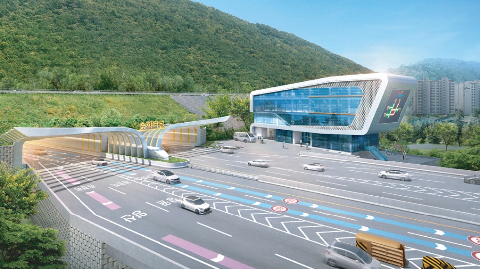
The city of Busan has approved the implementation plan for the Seunghak Tunnel private investment project and has published the topographical map, marking the beginning of the project. This Seunghak Tunnel is planned as a four-lane expressway with a total length of 7.69km, connecting the Eomgung Bridge in Eomgung-dong, Sasang-gu, to Chungjang-daero in Jung-gu.
The construction period is scheduled for 60 months from the start date, and If the city of Busan can commence construction in 2025, it aims to open in 2030. This project is expected to contribute to alleviating traffic congestion in Busan and promoting regional development.
The total project cost is 500 billion won (based on fixed prices), with a total investment amounting to approximately 622.5 billion won. Operations will be carried out for 30 years after opening. The project is led by the West Busan Urban Expressway Co., with participation from 11 companies including Hyundai Construction and Lotte Engineering & Construction. Notably, KB Seunghak Tunnel Specialized Private Investment Trust is responsible for 90% of the total investment.
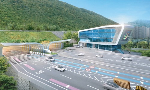
According to this notification, the road area has been defined as 277,513㎡, covering areas in Eomgung-dong, Sasang-gu, and Jung-gu, Central-dong 4-ga. The main passing areas are Sasang-gu, Saha-gu, Seo-gu, and Jung-gu. Additionally, three-dimensional road areas, including the above and below spaces of the tunnel section, have also been confirmed.

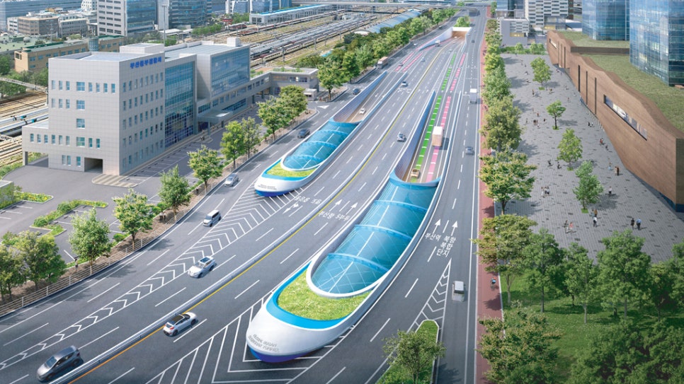
The Seunghak Tunnel is a key traffic route connecting West Busan and the city center. It is closely related to large-scale development projects such as the North Port redevelopment, Eco Delta City, and Gaduk New Airport, and is expected to significantly enhance traffic demand distribution and accessibility.
In particular, the connection with Eomgung Bridge is anticipated to further strengthen the traffic network in the West Busan area. Additionally, it will greatly contribute to alleviating traffic congestion in the city center through connection with the North Port underground roadway. This development will be a crucial factor in brightening the future of Busan.
Busan Metropolitan City Notification No. 2025 - 389
Approval of the Seunghak Tunnel Private Investment Project Implementation Plan and Notification of the Topographical Map
Regarding the "Seunghak Tunnel Private Investment Project," this is a notification pursuant to Article 15 of the "Act on Private Investment in Social Infrastructure" (Approval or Change of Implementation Plan, etc.), Articles 25 (Determination of Road Area), 28 (Three-Dimensional Road Area), 45 (Road Conservation Three-Dimensional Area), 48 (Designation of Expressway), and Article 24 of the Enforcement Decree of the same Act (Determination of Road Area, etc.), Article 30 of the "Act on the Planning and Use of Land" (Determining City and County Management Plans), Article 32 (Notification of Topographical Map regarding City and County Management Plans, etc.), Article 88 (Preparation and Approval of Implementation Plans, etc.), Article 8 of the "Basic Act on Land Use Regulation" (Designating Areas, Districts, etc.), and Article 22 of the "Act on Acquiring and Compensating for Land for Public Works" (Notification of Project Approval). This serves as a notification of the approval of the implementation plan, determination of road area, designation of three-dimensional road area, and designation of road conservation three-dimensional area, along with the decision of city management plans (change) and authorization of urban planning facilities business implementation plan, notification of topographical map, and notification of project approval.
October 1, 2025
Mayor of Busan Metropolitan City
1. Project Name: Seunghak Tunnel Private Investment Project
2. Project Overview
A. Location: From Eomgung-dong (Eomgung Bridge) in Sasang-gu, Busan Metropolitan City to Chungjang-daero in Central-dong, Jung-gu, Busan Metropolitan City
B. Scale: Length L=7.69km, Four-Lane, Expressway
C. Total Project Cost: 500 billion won (based on fixed prices as of March 1, 2016)
D. Total Investment Cost: 622.5 billion won
E. Construction Period: 60 months from the start date
F. Operation Period: 30 years from the commencement date
3. Project Implementer and Investors
A. Corporation Name: West Busan Urban Expressway Co., Ltd.
B. CEO: Baek Sang Hyun
C. Address: 75 Yulgok-ro, Jongno-gu, Seoul (Gyedong, Hyundai Building)
D. Investors and Shareholding Ratio (11 companies)
| Investor | Shareholding Ratio | Investor | Shareholding Ratio |
| Hyundai Construction Co., Ltd. | 4.50% | Hyopseong General Construction Co., Ltd. | 0.40% |
| Lotte Engineering & Construction Co., Ltd. | 2.00% | Kyungdong Construction Co., Ltd. | 0.40% |
| Hongwoo Construction Co., Ltd. | 0.60% | Hwangto General Construction Co., Ltd. | 0.35% |
| Youngdong Co., Ltd. | 0.53% | Dongseong Industry Co., Ltd. | 0.27% |
| Dongwon Construction Industrial Co., Ltd. | 0.50% | (Tentative Name) KB Seunghak Tunnel Specialized Private Asset Investment Trust | 90.00% |
| Jiwon Construction Co., Ltd. | 0.45% | Total | 100.00% |
※ Future changes to the investor names and shareholdings may occur based on financial agreements.
4. Construction Implementation Method
A. The project will be promoted in accordance with relevant laws and regulations such as the "Act on Private Investment in Social Infrastructure," the "Basic Act on the Construction Industry," and the "Construction Technology Promotion Act."
B. Implementation based on construction project management services.
5. Acquisition and Utilization Plan for Necessary Land
○ In accordance with the implementation agreement and implementation plan, the relevant authority shall take measures to acquire necessary land, etc., under the "Act on Acquiring and Compensating for Land for Public Works" so that the project implementer can use it free of charge.
6. Other Matters
○ Detailed documents and land (obstruction) records are available for public viewing at the Road Planning Division of Busan Metropolitan City and at the Construction Divisions of the relevant District Offices (Sasang-gu, Saha-gu, Seo-gu, Jung-gu).
※ The topographical map can be viewed at Land Eum (http://eum.go.kr).
- Busan Metropolitan City Road Planning Division
• 1001 Jungang-daero, Yeonje-gu, Busan, ☎ 051-888-2718
- Sasang-gu Office Construction Division
• 242 Hakgam-daero, Sasang-gu, Busan, ☎ 051-310-4702
- Saha-gu Office Construction Division
• 12 Nakdong-daero 398beon-gil, Saha-gu, Busan, ☎ 051-220-4695
- Seo-gu Office Construction Division
• 120 Gudeok-ro, Seo-gu, Busan, ☎ 051-240-4692
- Jung-gu Office Construction Division
• 120 Jung-gu-ro, Jung-gu, Busan, ☎ 051-600-4694
- West Busan Urban Expressway Co., Ltd.
• 75 Yulgok-ro, Jongno-gu, Seoul (Gyedong, Hyundai Building), ☎ 02-746-3748
7. Topographical Map: Available at Viewing Location
○ The notification of the topographical map as per Article 32 of the "Act on the Planning and Use of Land," Article 8 of the "Basic Act on Land Use Regulation," will be available at the viewing location, and separate publication of a map will be omitted.
8. Road Area Determination Document
A. Reasons for Determining Road Area
○ To improve mobility by alleviating traffic congestion on the major arterial routes in the urban area of Busan Metropolitan City and to deal with future traffic demands arising from developments such as Eco Delta City, Gaduk New Airport, and North Port Redevelopment, and to promote balanced regional development in Busan as a global hub city through road area determination.
B. Details of the Road Area Determination
| Type | Category | Route Number | Route Name | Location | Area (㎡) | Starting Point | Ending Point | Major Passing Areas | Total Length (km) |
| New | Metropolitan City Road | 12 | Jisa~Central (Seunghak Tunnel) | 658 Eomgung-dong Sasang-gu~15-7 Central-dong Jung-gu | 277,513.6 | 658 Eomgung-dong Sasang-gu | 15-7 Central-dong Jung-gu | Eomgung-dong Sasang-gu, Hadan-dong Saha-gu, Seo-Daesin-dong Seo-gu, Buyong-dong, Bumindong, Bosudong, Central-dong Jung-gu | 7.69 |
Details of the Three-Dimensional Road Area Determination
| Type | Category | Route Number | Route Name | Location | Area (㎡) | Starting Point | Ending Point | Major Passing Areas | Designated Section |
| New | Metropolitan City Road | 12 | Jisa~Central (Seunghak Tunnel) | 104-3 Eomgung-dong Sasang-gu~91 Central-dong Jung-gu | 224,544.1 | 104-3 Eomgung-dong Sasang-gu | 91 Central-dong Jung-gu | Eomgung-dong Sasang-gu, Hadan-dong Saha-gu, Seo-Daesin-dong Seo-gu, Buyong-dong, Bumindong, Bosudong, Central-dong | (Main Line) Toward Busan Station: 6,975m Toward Eomgung Bridge: 6,958m (Slope Tunnel) 1,267m |
Details of Designation of Road Conservation Three-Dimensional Area
| Type of Road | Metropolitan City Road | Route Number | 12 | Route Name | Jisa ~ Central (Seunghak Tunnel) |
| Designated or Changed Sections | - Location towards Busan Station: Eomgung-dong, Sasang-gu, Busan Metropolitan City~Central-dong Jung-gu L=6,975m; towards Eomgung Bridge: Eomgung-dong, Sasang-gu, Busan Metropolitan City~Central-dong Jung-gu L=6,958m; Slope Tunnel: Hadan-dong, Saha-gu, Busan Metropolitan City~Seo-Daesin-dong, Seo-gu L=1,267m - Horizontal range: Tunnel underground facilities width + 0.5m on each side - Vertical range: Tunnel underground facilities top height and bottom depth + protection layer of 6m each | ||||
| Reason for Designation | - To protect rational land use and road structure in the tunnel section (Sasang-gu, Saha-gu, Seo-gu, Jung-gu) of the Seunghak Tunnel, the underground space, including the protective layer from above and below tunnel facilities, will be designated as a road conservation three-dimensional area. | ||||
According to Article 30 of the "Act on the Planning and Use of Land" (Decision of Urban and County Management Plans) and Article 32 of the same Act (Notification of Topographical Maps regarding Urban and County Management Plans, etc.), as well as Article 8 of the "Basic Act on Land Use Regulation" (Designating Areas and Districts), the determination of urban and county management plans and topographical map notification matters.
A. Urban Planning Facility (Road) Document
| Type | Scale | Function | Length (m) | Starting Point | Ending Point | Usage Type | Major Passing Areas | Initial Decision Date | Remarks | |||
| Grade | Type | Number | Width (m) | |||||||||
| New | Metropolitan Road | 3 | 53 | 29~93 | Main Arterial Road | 7,690 | 651-42 Eomgung-dong, Sasang-gu | 15-7 Central-dong Jung-gu | Expressway | Three-dimensional Decision, Partial overlapping decisions for roads, parks, transportation plazas, etc. | ||
Reasons for Road Decision
| Previous Road Name | New Road Name | Change Details | Reason for Change |
| - | Metropolitan Road 3-53 | ⦁New road - Length: 7,690m - Width: 29~93m | ⦁The construction of the Seunghak Tunnel leads to the establishment of a new expressway (underground road) |
Details of Three-Dimensional Urban Planning Facility (Road) Decision Document
| Type | Map Display Number | Facility Name | Location | Type | Three-Dimensional Decision Range | Initial Decision Date | Remarks | |
| Starting Point | Ending Point | |||||||
| New | Metropolitan Road 3-53 | Underground Road | 104-3 Eomgung-dong Sasang-gu | 91 Central-dong Jung-gu | Length (m) | ⦁Towards Busan Station: 6,975m ⦁Towards Eomgung Bridge: 6,958m | - | - |
| Width (m) | 29 ~ 93m | |||||||
| Height (Underground) Note 1) | ⦁Between -78.4m and +21.1m based on average sea level | |||||||
Note 1) The height of the three-dimensional decision (relative to average sea level) includes the height of the upper and lower ends of the structure plus a protection layer (6m).
#SeunghakTunnel, #PrivateInvestmentProject, #BusanTransport, #TunnelProject, #Expressway, #RoadInfrastructure, #BTOProject, #HyundaiConstruction, #WestBusanUrbanExpressway, #NorthPortRedevelopment, #EcoDeltaCity, #GadukNewAirport, #WestBusanTransportInnovation, #RoadAreaDetermination, #ThreeDimensionalRoadArea, #RoadConservationThreeDimensionalArea, #UrbanPlanning, #TopographicalMapNotification, #60MonthConstructionPeriod, #2030Opening, #ProjectImplementer, #InvestmentShare, #PrivateInvestmentProject, #SocialInfrastructureInvestment, #UrbanConnectorRoad, #AccessibilityEnhancement, #TrafficHub, #LogisticsAxis, #BusanFutureCity
Frequently Asked Questions (FAQ)
Q. What is the main overview of the Seunghak Tunnel Private Investment Project?
The Seunghak Tunnel is a 7.69km four-lane expressway from Eomgung-dong in Sasang-gu to Central-dong in Jung-gu, with construction starting in 2025 and aiming to open in 2030.
The Seunghak Tunnel Private Investment Project is a project to establish a 7.69km four-lane expressway that connects Eomgung Bridge in Eomgung-dong, Sasang-gu, and Chungjang-daero in Central-dong, Jung-gu, Busan. The total project cost is 500 billion won, and the overall investment is approximately 622.5 billion won. The construction period is scheduled for 60 months from the start of construction, and the city of Busan is promoting the project with the goal of starting in 2025 and opening in 2030.
Q. Who are the implementers and participating companies in the Seunghak Tunnel project?
The project is implemented by West Busan Urban Expressway Co., with participation from 11 companies, including Hyundai Construction and Lotte Engineering & Construction, and KB Seunghak Tunnel Specialized Private Investment Trust.
The project implementer is West Busan Urban Expressway Co., Ltd., and a total of 11 companies, including Hyundai Construction, Lotte Engineering & Construction, and Kyungdong Construction, are participating in construction and investment. Notably, KB Seunghak Tunnel Specialized Private Investment Trust is the main investor, responsible for approximately 90% of total investments. The operation period will continue for 30 years after opening.
Q. How were the road area and passing regions for the Seunghak Tunnel determined?
The road area is set at 277,513㎡, covering Eomgung-dong in Sasang-gu and Central-dong 4-ga in Jung-gu, passing through Sasang-gu, Saha-gu, Seo-gu, and Jung-gu.
According to this notification, the road area for the Seunghak Tunnel has been determined as 277,513㎡ in the areas of Eomgung-dong, Sasang-gu and Central-dong 4-ga in Jung-gu. The project corridor passes through parts of Sasang-gu, Saha-gu, Seo-gu, and Jung-gu, and three-dimensional road areas, which include the above and below spaces of the tunnel section, have also been designated. This holds significance as an urban planning facility to alleviate traffic congestion and respond to future traffic demands.
Q. What impact will the Seunghak Tunnel have on transportation and development in the Busan area?
It contributes to easing traffic congestion and enhancing accessibility to major projects by strengthening connections between West Busan and the city center.
The Seunghak Tunnel is a major traffic route that directly connects West Busan and the city center, and it is correlated with large-scale development projects such as the North Port redevelopment, Eco Delta City, and Gaduk New Airport. This will help to distribute the increasing traffic demand and significantly improve accessibility in the West Busan area. In particular, through the connection with Eomgung Bridge, it is expected to strengthen the traffic network in West Busan, and the connection with the North Port underground roadway will play a crucial role in alleviating traffic congestion in the city center.
Q. How are urban planning and administrative procedures related to the Seunghak Tunnel Private Investment Project conducted?
The approval of implementation plans, determination of road areas, and notifications of topographical maps have been completed, in accordance with relevant laws such as the Act on Private Investment in Social Infrastructure.
The project has completed administrative procedures such as the approval of implementation plans, determination of road areas, and designation of three-dimensional and conservation areas, along with changes to urban and county management plans and notifications of topographical maps, in accordance with relevant laws including the Act on Private Investment in Social Infrastructure, the Road Act, and the Act on the Planning and Use of Land. Land acquisition will be carried out under related public work laws, and required documents and topographical maps will be available for public viewing at the Busan Metropolitan City and district offices.